MapRunner

MapRunner seamlessly integrates your diverse data sources with our cutting-edge, AI-empowered engine, enabling users to:
-
Directly extract and manage raw data from storage.
-
Access images from any desired location in real-time. This is useful for transportation departments and utilities agencies.
-
Access to comprehensive road data, allowing users to analyze roads and critical safety assets over the course of multiple years.
-
Upload and store their own data securely on the cloud or their private servers.
-
Identify road assets and put them on maps with high accuracy.
-
Determine asset types and locations.
-
Tracking asset changes over years.
With real-time access and reliable insights, you can effortlessly view roads, conduct safety inspections, and make well-informed decisions from the comfort of your desk.
Key Features
Annotate and Markup Road Assets
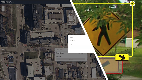
Annotate and Markup Traffic Signs and Road Assets. MapRunner offers powerful tools to annotate and markup traffic signs and road assets. With these tools, you can effectively highlight road status, create maintenance plans and progress reports, identify specific road conditions, designate new and future asset locations, and mark assets for removal. Additionally, MapRunner enables you to add detailed notes, comments, decisions, and instructions for the maintenance team, facilitating seamless communication between managers, decision makers, and the on-ground maintenance team. All of this can be accomplished conveniently from your desk, ensuring efficient sharing of information and streamlined collaboration across teams.

Multi-Year, Multi-Image Road Asset Tracker
Track and visualize road assets across multiple frames over multiple years. MapAssets identifies new and missing road assets, and reports them back to users. This allows users to create a Multi-Year sign dataset and view their history. Tracking road assets in consecutive images and over years helps in removing datasets redundancy and captures road changes over time.


Multi Speed Navigator
Experience the future of road asset inspection with MapRunner. Instead of risking safety, wasting resources, and facing speed limits by inspecting road conditions in-person from your vehicle, take a virtual road trip with us. MapRunner enables you to drive roads and view assets at your desired speed, even up to a thrilling 200 MPH, without compromising safety, wasting resources, or contributing to emissions. Embrace convenience, efficiency, and sustainability by exploring roads from the comfort of your desk.
AI-Powered Asset Extraction
Leverage state-of-the-art AI to detect and extract road assets from street images and video logs — regardless of the capture device. Whether you're using dashcams, smartphones, or drone footage, our technology delivers unmatched accuracy and scalability.
GPS Localization from a Single Image
Instantly localize and map assets using just one image. Our AI integrates geospatial intelligence to pinpoint exact GPS coordinates — simplifying inspections and streamlining maintenance workflows.
Change Detection & Timely Intervention
Automatically detect missing or newly added road assets due to events like traffic accidents. Our system flags these changes so Departments of Transportation (DOTs) can respond proactively and avoid legal liability windows.
Visibility Analysis for Road Safety
Ensure traffic signs and critical assets remain visible over time. Our solution detects changes in visibility due to environmental factors — such as foliage growth — and helps schedule timely trimming or asset repositioning.
MIRE Compliance Made Simple
Stay fully compliant with federal Model Inventory of Roadway Elements (MIRE) standards. Our technology captures all required elements, ensuring accurate, audit-ready records.
Linear Referencing System (LRS) Support
Track asset data with full compatibility with your existing Linear Referencing Systems, supporting both spatial and temporal tracking for a complete lifecycle view.
Spatial & Time Tracking
Monitor asset conditions and changes over both time and space. Get historical insights, plan better maintenance, and optimize resource allocation with dynamic data visualization tools.
Customizable to Fit Your Own Needs!
Our suite of tools and services is designed with a strong emphasis on customization, ensuring they can be tailored to meet your specific requirements. You have the flexibility to choose from a variety of base maps that best align with your preferences and objectives. Additionally, our solutions enable you to visualize your state map exclusively, focusing solely on the information that matters to you. Furthermore, our tools possess the capability to identify and highlight state-specific assets, empowering you with targeted insights and analysis. With these versatile features and more, you can fine-tune our tools and services to create a truly personalized and tailored experience that perfectly aligns with your unique needs.

General Options
-
Visibility of Nearby Sign bounding box in the street viewer.
-
Frame images from closest to the farthest.
-
Set icon visible range (Visible When Zoom within specific level).
-
Configuration for bounding box.
-
Interactive bounding box (click and redirect the point on map).
-
Label and Icon info on bounding box.
-
Have traffic sign label and icon at the corners.
-
User can hover the icon to zoom out the symbol.
-
Support multiple signs display.
- Zoom In/Out.
-
Recenter map about a selected point.
-
Near by sign Visibility of Nearby Sign bounding box in the street viewer.
-
Users can directly click the bounding box to see the traffic sign they are looking at.
-
Multiple Browser Support.
What Are the Benefits of Using MapRunner?
-
Detailed maps with road assets information
-
State-of-the-art AI technologies to extract road assets and perform analysis
-
Rich visuals combined with comprehensive metadata
-
Go Green and reduce emissions! Efficiently navigate roads from the comfort of your desk
-
Practical tools to generate reports, extract, and share information with teams
-
Dedicated technical support expert at your service
